
A Revolution on the Digital Geography: How Big Data Changes From Wuhan to the World (Chinese / English)
數字化地理建設:從全球到武漢
數字化地理建設:從全球到武漢
原文發表于2009年十一月,原文有刪改
(Originally published in 2009, edited in 2017)
by Anqi Yang

Besides navigation and local interest searching, the Google Earth platform is widely applied in geography database collection, publication, and site analysis in a variety of fields, such as architectural design site studies, real estate properties evaluation, new events publication, simulation, and other relevant services. Some plugins of Google Earth are very helpful for the researchers and clients, for instance, it's quite easy and convenient to present out a draft survey on a certain area by using the measuring tools in the platform.

上圖顯示汶川地區三維數字影像,銜接維基百科,顯示美國官方衛星所測地質破壞圖片,可搜索有關信息。
The above image shows the three-dimensional digital view of the Wenchuan area, convergence to Wikipedia (left), showing the geological damage diagram resealed by the US government, users can search for further information and links.
The above image shows the three-dimensional digital view of the Wenchuan area, convergence to Wikipedia (left), showing the geological damage diagram resealed by the US government, users can search for further information and links.

利用谷歌地球觀看地理奇觀時間很興奮的事情,如羅布泊,“地球之耳”的影像。
Lop Nur from space, a view from Google Earth. Lop Nur used to be an ephemeral lake many years ago and in recent decades, the lake is totally dry. The top left photo shows the landscape of the central area of the lake.
Lop Nur from space, a view from Google Earth. Lop Nur used to be an ephemeral lake many years ago and in recent decades, the lake is totally dry. The top left photo shows the landscape of the central area of the lake.

The View of Menhaden at nightfall, New York.

在2009年2月2日,Google Earth發布了最新的5.0版,新版本的主要目標是讓用戶能全面的了解我們生活的地球。其主要新增加的功能包括,Google Ocean(谷歌海洋)、大氣層功能、提供曆史圖像功能,能夠讓用戶實現時空倒流般的地球旅行,浏覽火星圖片功能。新增加的Google Ocean(谷歌海洋)功能,其提供的數據對科學研究具有重要參考作用,通過Google Ocean功能,用戶將可以查看海洋和部分海底的美景,包括巴哈馬群島、紅海和大堡礁海域等潛水勝地,查看水下世界的三維圖像,還可以浏覽有關海洋科學的文章和視頻,這一項目還提供了詳盡的海洋環境數據,使公衆進一步了解氣候變化給海洋造成的負面影響。新的曆史圖片功能可以讓用戶觀看地球表面某一點隨時間變化而變化的存檔衛星圖片。
On February 2, 2009, Google Earth released the latest version 5.0, the new version of the main goal is to allow users to have a comprehensive understanding of the Earth we live in. Its main additions include the Google Ocean, the atmosphere feature, historical images viewer, which allows users to achieve time and space back to earth travel and browses the 3D views of Mars. The new Google Ocean feature, which provides data on the importance of scientific research, through the Google Ocean function, users will be able to view the ocean and part of the beauty of the sea, including the Bahamas, the Red Sea and the Great Barrier Reef waters such as diving to view the three-dimensional images of the underwater world, and to browse articles and videos on marine science. The project also provides detailed marine environmental data to enable the public to gain a better understanding of the negative impacts of climate change on the oceans. The new historical picture feature allows users to view archival images of the Earth's surface with varying changes over time.

Baidu Map released the global map in the past couple of years, and as we can see above is the screenshot of the Baidu Map zoomed near the central park New York. The generic languages for the map sets are English and Chinese.

The weather chart of East Asia, released in November 2009, presents a dramatic upheaval in the northeast, east, and southeast of China and the forecast shows that the temperature drops to 0 degrees Celsius.

Overlooking Mount Olympus on Mars from 105 km high altitude, the altitude of the volcano is nearly 25 km, which is the highest mountain in the solar system.

The photograph on Mars surface, released by the USSA

The Google Earth Moon Plugin engine allows users to follow the views of the historical landing cars to see the moon surface in 360 degrees. The above image shows the surrounding geographic situation of the US lunar base where Apollo 15 landed.

This is a Google Maps screenshot (Wuhan Hankou), which supplies traffic routes navigation and map search in different map layers such as terrain, satellite, geographic information. Similar to Google Earth, by searching general information through Google Maps is more efficient and convenient. Google Maps is an electronic map service provided by Google, including local detailed satellite photos. Google Map is able to provide three views: the vector map (traditional map), which includes regional and traffic and business information; the resolution of the satellite photos, which presents the satellite real images of the entire surface of the Earth; the terrain view, which demonstrates terrain and contours clearly.
The picture shows the city fabric of Wuhan Wuchang and Hankou, supported by the Google Map Android version. Google Map Android mobile phone version allows users to directly touch or slide the full three-dimensional city map on the mobile screen, and its layer is very similar to the desktop version, which embraces satellite view, contour lines view, Google Earth 3D satellite image and the three-dimensional image of the Andrews version.
很多房地產中介公司都投入到實景看房系統中,比如房天下的VR看房平臺,該平臺不僅可以允許客戶720度觀看樓盤,而且提供了一些城市空中VR的場景供客戶觀摩。以下的圖片便是房天下武漢以及上海的VR看房平臺系統。
Many real estate agencies have invested in the real-life viewing system, such as the Fang Tian Xia VR viewing platform for the properties. The platforms not only allow customers to view the real estate 720 degrees but also provide some urban aerial VR scenes for customers to observe. The following Image shows the Wuhan and Shanghai VR viewing platform system.

Wuhan Aerial VR Platform (click the link)
Shanghai Aerial VR Platform (click the link)

Undeniably, Google Maps, and Google Earth played an important role in the 2009 China Sichuan Wenchuan earthquake relief process. Disaster relief front-line staff published detailed geographical coordinates of the various support requests on Google Maps. It might be considered as the first time in the global disaster relief for the full use of the digital geographic system and its latest technology. The above is the screenshots of the topographic map, showing the west of Chengdu 213,317 National Road satellite remote sensing geometric mapping, contours are clearly visible.

The above map shows the complexity of the terrain condition of the San Francisco Urban area, which is from Google Maps.
 下圖顯示深圳市民廣場及中央商務區一帶三維地圖:
The following image presents the sky view of the civic center with the great plaza in Shen Zhen, Guang Zhou, China.
 下圖爲E都市重慶市中央CBD,其繁華程度可見一斑,無怪乎被美國官方評價重慶爲中國的曼哈頓:
The following image shows the sky view of the CBD area of Chong Qing, China which is one of the largest cities of China.


 A three-dimensional version map (e-dushi or dushiquan) presents the sky view of Shanghai Bund and Pudong.
 下圖爲武漢市綠地查詢系統頁面
Green land search page, from Wuhan Land Resource And Planning Bureau
 下圖爲武漢市中心城區四線控制查詢系統頁面:
A digital map search engine of the city of Wuhan, from Wuhan Land Resource And Planning Bureau
 下圖爲武漢市管線電子地圖查詢系統定位圖,覆蓋全市區;顯示漢口大洋百貨、市工商聯合會一帶市政管網。該系統爲市政、規劃、建築等行業提供可靠的、確切的施工、設計依據,屬武漢市數字地理建設範疇:
The following image is the infrastructure query system of the city of Wuhan; this map shows the municipal water supply, drainage pipes, gas and cable networks of the street corner of Hankou Ocean Department Store, City Federation of the Industry, and all these city blocks are within the commercial district of Hankou. The system benefits to the municipal, planning, construction and other industries a lot, which could provide a reliable, accurate construction, design basis, This platform is one essential section of Wuhan Land Resource And Planning Bureau.
 下圖顯示武漢市土地出讓金級別圖,圖中顯示江漢區中心城區級別爲一、二級;武昌區中心城區爲三級:
The following map-diagram shows the Wuhan City land transferring fee levels from highest areas(red) to lowest areas(light green), users (usually are the real estate developers) could identify that the central city area of Jianghan District is level one or level two, and the central area of Wuchang district is level three.
 下圖爲市土地挂牌查詢系統,所示爲武漢市積玉橋某片已成交的土地交易信息:
The following diagram-map is the city land listing query system,
 下圖爲在建項目查詢系統截圖,所示武漢市積玉橋金地國際花園項目紅線圖,聯體別墅、高層住區建築清晰可見:
Users could identify the control line drawings of the high-rise residential projects, townhouses and surrounding survey drawings through this document. This search engine is established by Wuhan Land Resource And Planning Bureau.

除了美國的Google地球和地圖地理信息平臺服務,中國也有相應的數字化地理信息和城市建設項目資源平臺服務,二零零九年七月,武漢市三維數字地圖系統已全面建成,其覆蓋面積居全國其他城市之冠,武漢一度成爲“最數字化的城市”,其系統尚在政府內部作為管理系統運營。(參見長江商報2009年七月份相關報導) “數字武漢—國土資源和規劃網”, 網上提供了城建資源信息,包括電子城市地圖、規劃(綠地、四線控制、綜合規劃、重點規劃等)、國土(出讓、拍賣)、在建項目及拆遷等領域如全市的測繪圖、城市規劃圖、改建拆遷測繪圖等。
除了武漢當地政府的三維地理信息平臺系統外,全國已經兩個較大的獨立運營商“都市圈”和“E都市”分別上線了靜態三維城市信息地圖,下圖爲北京都市圈三維城市模型,顯示立體黃頁——北京東方君悅大酒店信息:
The above image shows the three-dimensional view of the image of the Hall of Supreme Harmony, clearly demonstrates the main structure of the architecture, interior decoration, and other elements.
Compared to the Google Earth geographic information platform services, China has developed its own corresponding digital geographic information and urban construction project resource platform. In July 2009, the three-dimensional digital map system of Wuhan has been fully developed and operated by Wuhan Land Resource and Planning Bureau, till now, for confidential and security reasons, some services of the system could be only viewed and operated by the government. "Digital Wuhan - Land and Resources and Planning Network", the Internet provides information on urban construction resources, including electronic city map, planning (green, four-line control, comprehensive planning, ), Land (transfer, auction), construction projects and demolition and other fields such as the city's mapping, urban planning, alteration demolition mapping.
Besides Wuhan's three-dimensional geographic information platform system released by Wuhan Land Resource and Planning Bureau, China has another two large independent operators "metropolitan area"(dushiquan) and "E city"(edushi), which released the static three-dimensional city information map to the public. The 3D map is essentially a three-dimensional yellow page, for instance, users could find the Grand Hyatt Beijing Hotel information on this map in 3D view version as it shows below.

The following image presents the sky view of the civic center with the great plaza in Shen Zhen, Guang Zhou, China.

The following image shows the sky view of the CBD area of Chong Qing, China which is one of the largest cities of China.

下圖為重慶市區照片,圖片來源www.goodfon.com The following image is a photo of the city of Chong Qing

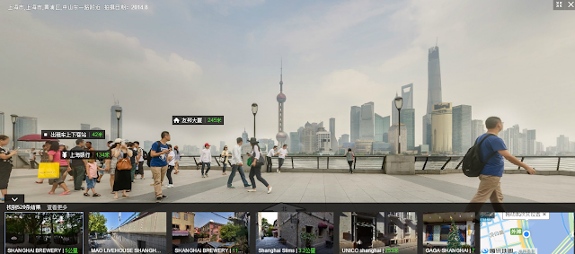
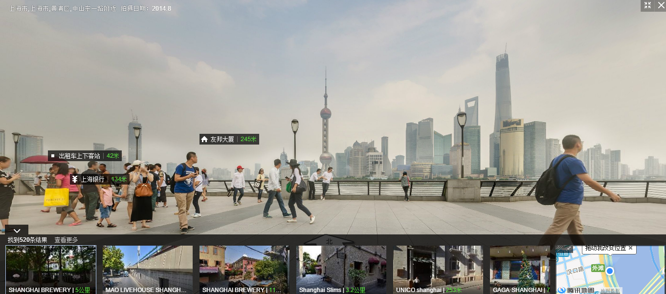
2013年,國內正式推出類似谷歌地圖街景服務的SOSO地圖,下圖爲上海從外灘看陸家嘴景觀,同時可以同時對比三維地圖對外灘進行查詢。
Released in the year of 2013, Soso Map is another important digital map search engine in China, besides the regular services, it also supplies the 360-degree street views, which means this type of search engine is very similar to Google Map. The following images are the street view of Shanghai Bund and its navigation page.


Green land search page, from Wuhan Land Resource And Planning Bureau

The picture below shows the four-line control query page of the central area of Wuhan :
下圖爲該系統武漢市電子地圖截圖,數據庫很完善:
A digital map search engine of the city of Wuhan, from Wuhan Land Resource And Planning Bureau

The following image is the infrastructure query system of the city of Wuhan; this map shows the municipal water supply, drainage pipes, gas and cable networks of the street corner of Hankou Ocean Department Store, City Federation of the Industry, and all these city blocks are within the commercial district of Hankou. The system benefits to the municipal, planning, construction and other industries a lot, which could provide a reliable, accurate construction, design basis, This platform is one essential section of Wuhan Land Resource And Planning Bureau.

The following map-diagram shows the Wuhan City land transferring fee levels from highest areas(red) to lowest areas(light green), users (usually are the real estate developers) could identify that the central city area of Jianghan District is level one or level two, and the central area of Wuchang district is level three.

The following diagram-map is the city land listing query system,

Users could identify the control line drawings of the high-rise residential projects, townhouses and surrounding survey drawings through this document. This search engine is established by Wuhan Land Resource And Planning Bureau.

注:1、以上相關信息參見《數字城市空間數據基礎設施建設與應用》(科學出版社)。
2、相關資源參見武漢市的“數字武漢—國土資源和規劃網”、谷歌地球、“E都市”、“都市圈”、“湖圖”網站。
3、本文部份參考了2009年Google Earth的官方說明,没有包括该系统的最新功能。
Image of Chong Qing, https://www.goodfon.com/wallpaper/kitay-chuncin-reka-most.html
重要外部銜接/Important external links
都市圈 http://www.o.cn/
e都市 http://www.edushi.com/mapcity.html
soso地圖 http://map.qq.com/
智慧武漢 http://www.digitalwuhan.gov.cn/
房天下http://www1.fang.com/
No comments:
Post a Comment